-
Dec 22, 2022, 12:14 pm2.5k ptsInsanely Great Special Content
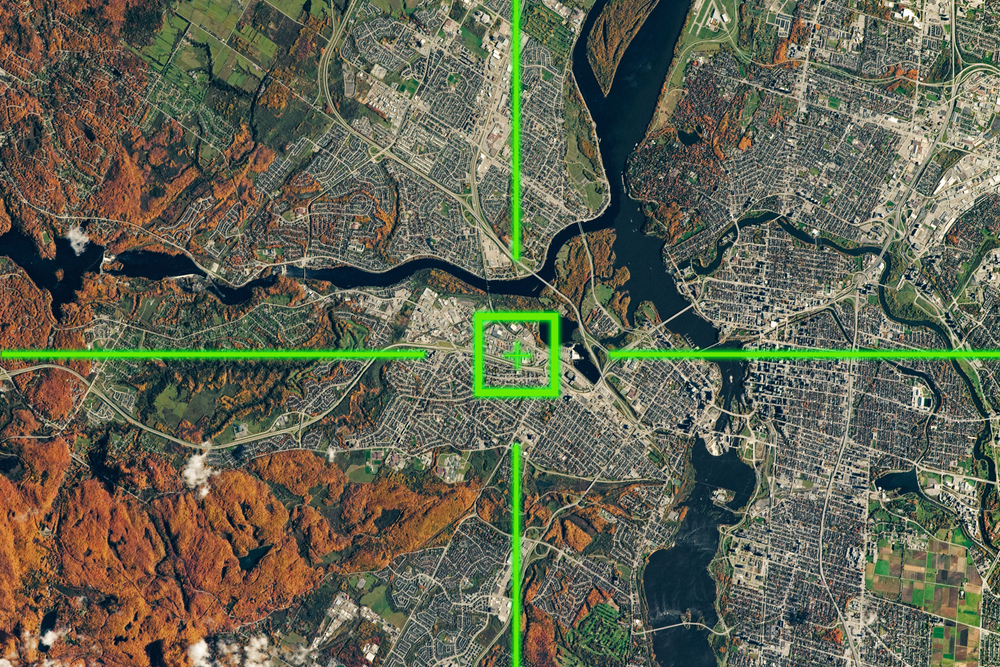
Everyone living in the modern world deals with satellite data every day, be it for weather forecasts or navigation. Apart from solving everyday tasks, space imagery has a great number of applications: monitoring of fires, floods, man-made disasters. Another main direction is everything that is related to search, assessment, accounting and use of natural resources, for instance, observance of license area borders and environmental norms during mining.
Satellite data application in agriculture should be mentioned separately. Today we observe both intensive development of the agricultural sector and active penetration of information technologies into farming practices. The issue of precision farming is becoming more and more urgent, and here satellite imagery analysis comes to the aid of agricultural producers.
As cloud computing, AI, and related technologies keep constantly developing, satellite images of Earth become an even more powerful tool for retrieving valuable insights on what happens on the Earth's surface and even under. And with the occurring space commercialization, satellite pictures become much easier to access for different purposes. You can find daily satellite images for your needs just by making a few clicks when years ago this opportunity was open only to governmental institutions and professionals.
Satellite Imagery Characteristics
The main characteristic of a satellite image is its resolution - a quantitative indicator that characterizes the image quality, level of detail, and the possibility of using it for solving a certain range of tasks. However, when it comes to satellite pictures, there are different types of resolution to consider.
The spatial resolution of digital images is understood as the size of the minimum image element - a pixel on the ground. Therefore, the higher the spatial resolution, the better will be the detailing on the picture. Satellite imagery spatial resolution varies from low to ultra high of several centimeters.
Spectral resolution is determined by the width of the spectral bands in multispectral and hyperspectral imagery and is measured in nanometers or micrometers. Panchromatic images have the lowest spectral resolution of hundreds of nanometers, and hyperspectral images have the highest, up to 10 nm. In other words, spectral resolution tells you about the ability of a satellite sensor to resolve features in the electromagnetic spectrum.
Temporal resolution stands for the frequency with which the satellite passes over the surface area of interest. It is important when studying a series of images, for example, when studying the dynamics of forests. Modern satellites offer quite high temporal resolution, offering close to real time satellite view of the planet.
Accessing Free Satellite Imagery Fast and Easy
To lay eyes on satellite imagery a decade ago, one had to have deep technical expertise and understanding of the sector. But now, free satellite imagery is easily available to anyone willing to have it through different solutions like Google Maps, for example. The drawback is that the imagery is usually out of date and of poor resolution. Institutions like the European Space Agency also offer free satellite pictures, but they still require strong technical knowledge and expensive software to be fully exploited. So, let's go through some of the best solutions that enable free and easy access to historical and most up to date satellite images for different purposes.
EOSDA LandViewer
This digital satellite imagery catalog was developed by EOS Data Analytics, a company with deep knowledge and experience in satellite imagery analytics. The tool allows for only searching for satellite pictures but also for their instant analysis and results visualization, depending on the purpose and object of research. For that, the platform offers different spectral indices to choose from. More so, the users can create their own indices combining available bands.
Ten free medium-resolution images are available daily, while high and very high-resolution images need to be paid for. The users also have the option of narrowing down their search by choosing the area of interest. And an already processed image can be easily downloaded or stored in a cloud to use when necessary.
Comparing images of the same area taken by different satellites and on different dates, users can easily detect any occurring changes. For better changes visualization, the tool offers time-lapse animation.
NASA Worldview
Apart from free satellite pictures of Earth, NASA Worldview offers access to different scientific products, which help retrieve valuable information on natural disasters and the threats they pose. The filter to choose the discipline of interest is also available.
Digital Globe Open Data Program
This program enables users to retrieve the most recent satellite images from locations where wildfires, hurricanes, floods, or other natural disasters took place. These images can be used for advanced analysis of disaster's impact, scale of destruction, and mitigation planning. Sample images are available for download.
Google Earth Pro
This software can be used for free visualization, analysis, and creation of geospatial data. The users can view very high-resolution satellite pictures, upload or download geospatial data in its native interoperable file format, and find locations they are interested in.
Trending Today on Tech News Tube


Follow all of the top tech sites in one place, on the web or your mobile device.